We've had our spell of unseasonably warm weather here on the Island, and just as it turns colder, down to single digit Celsius weather, I decide it's time to enjoy the afternoon and get out on my Versys for a quick boot around Bedeque, Prince Edward Island, with a visit to Sea Cow Head lighthouse out on Sevenmile Bay near Borden-Carleton PE.
The shoreline along Sevenmile Bay PE
Borden-Carleton to Sea Cow Head to Salutation Cove to Dunk River PE
Borden-Carleton to Sea Cow Head to Salutation Cove to Dunk River PE
I knew it was going to be a cooler ride this afternoon, so underneath my heavy cotton duck riding pants I had a pair of track pants on, and wore my heated jacket on under neath my leathers, but never had it plugged in this afternoon. It was brisk enough on the highway for me to need to turn on the heated grips while wearing my summer gloves, and as I rode along the highway headed towards the Tim Hortons at the Borden-Carleton Esso, I found it was raining, and worried that the weather forecast for this afternoon might have been off by a bit, but the rain was only spitting and I soon rode out from underneath it, and on into town where I filled the tank, then got a cup of coffee to fill me.
I left my pit stop and headed North on 118, then wound my way out to Campbells Shore on Sevenmile Bay.
I had Sea Cow Head in mind as a destination, as I haven't visited it this year, and I wanted to get some photographs of the shoreline in this noon light.
Campbells Shore PE
Looking across the bay at Sea Cow Head lighthouse
Campbells Shore is a deadend dirt road, so I had to double back out to 119 to make my way further West into Fernwood, then onto Sea Cow Head Road, which leads you to Lighthouse Road.
The Sea Cow Head lighthouse
Sea Cow Head looking towards Campbells Shore
Can you see the Confederation Bridge in the background? This is a lobster boat just off the headland, checking and baiting his traps. It's a strange sort of pirouet as they haul in each trap of the set, pull out the rock crabs and lobster, then re bait the traps and lay out the set, with two buoys to mark each end. The buoys are specific to the boat, and the other fishermen will know exactly who owns the set of traps just by the design and colour of the buoys.
The Versys gets you there
I wonder what this was used for and how long it has been embedded in the ground like that?
The salt sea air is highly corrosive to metal, so if you told me this was only ten or fifteen years old I would believe you. My friend Danny takes great care to ensure that all the fittings used in and on the boat can handle the sea water, as it really acts quickly to oxidize and corrode metal.
Sea Cow Head Lighthouse, Sea Cow Head PE
I think I covered all the angles there, so it was time to go, but not home, I wasn't ready for the ride to end, so I headed over to Leard Mill road and stopped at Wrights Pond to see what the fall colours were like, but I think they will peak later on this week, as there is a frost warning tonight that should kick the sap into high gear.
Wrights Pond, Bedeque PE
Bradshaw River, the other side of Wrights Pond
I wimped out when I saw the grass growing up between the road here, as it had rained earlier in the morning and standing puddles on a clay road is not something I want to risk taking my Versys down, regardless of the fantastic grip of the Shinko 705s, as they load up quickly in wet clay and become slicks in a matter of seconds, so discretion is the better part of valour so they say, and I did a u-turn and headed back out to the road.
I'm a wuss
Route 112 heads through Bedeque, then carries on out to the point opposite the city of Summerside, and as I'd seen it many times from Holland College located right on Summerside Harbour, I really wanted to see the opposite view from Salutation Cove.
Summerside PE as seen from Route 112
damp clay roads in the treeline
Salutation Cove PE
Unfortunately someone has been doing some illegal dumping on the shoreline, as evidenced by the waste concrete in the photo above.
The sand bar and it's lighthouse of Summerside Harbour
Keep to the right unless you are wearing your water wings
Salutation Cove PE
And now its time to head back out on 112 and head into Summerside to pick up some dog and cat treats.
There were quite a few ducks in the water but not enough to warrant stopping for a photo, as the light was in the wrong spot, and I'd have been taking a picture into the sun of a flock of geese in the distance, so I just rolled on past Summerside, then turned East at Traveller's Rest roundabout (beating the transport truck by going too fast through the on ramp, oh yeah!) and pulled in to find that puppy training class was just getting out, and I fell in love with many of the young puppies that were eagerly spilling out of the doors and straight at the bad biker boy. Heaven!
Zippy got a knuckle buster, and I bought some catnip and a couple of toy mice for Odie the cat.
Time to head home and have a late lunch...
Route 110 overlooking the Wilmot River bridge
The tops of the potato plants have been sprayed to kill the plants, and the field will be harvested soon, dry weather preferred to wet.
Dunk River with a few fisherman
Harvesting the potatoes at Dunk River PE
And that's pretty much it. Rolled in to find I had a fleaBay bit in the mail which makes me very happy, and to find my brother-in-law Cap'n Kirk playing with his 2017 Triumph Tiger XCx trying to start it. He's a bit ticked off, and has been all over the forums to find that it is a common glitch with the bike to fail to start, blow lots of white smoke in the process, then to promptly start and never have the issue again. His bike is still in the "Won't stay running" phase, and he's got the battery on a charge to try again. "It's going back!" he muttered as we headed into the house.
On a good note, Zippy was really happy to see me and smell my bag and his new bone. :)
Late in the season I got bit with the touring bug, and I've managed to cut my costs thanks to the inspiration of Vagabondesss.com and following her Facebook adventures. Safia motivated me to get out there and enjoy myself while waiting for employers to beat down my door with job offers.
The world's longest covered bridge in Hartland New Brunswick
I messaged my KLR riding buddy Brian where he wanted to go this weekend, and he replied that he wasn't able to go this weekend, so I thought I'd take three days and see if I could pare down my riding budget by packing along all the food I would need for the weekend instead of dining out and simply cooking a breakfast at the campsite.
I've also been watching Mark Victor of BikerBits.com.au review gear and provide great proven advice for using a motorcycle kitchen. From learning how to pack fresh eggs to survive the odd wheelie and pothole, to what sort of meal to make with the potato that you packed along.
Right, so I struggled with an old Garmin topo map and the new Basecamp software and tried to bend it to my will to plot out the ultimate three day route that would take me off of the highways and onto the byways of New Brunswick that Rob Harris and Zac Kurylyk of CMG fame had shown me on the Dawn 2 Dusk rally years ago.
The Plan for the next three days
While that was happening, I found an old thermal grocery bag with a zippered closure lying in the garage, coerced my Nephews into picking up some eggs, disappointed the dog by packing up a tin of Spam Bacon by Hormel, and got some laundry going. I even washed off the dust of the Cape Breton Island's Highland Road that Brian and I had covered the bikes with last Sunday.
Day 1 - Borden-Carleton PE to Blacks Harbour NB - 482 km
Day 1 - Borden-Carleton PE to Blacks Harbour NB - 482 km
Suddenly it was D-Day and time to let out the clutch and start the ride with a breakfast at Anna's Country Kitchen in Crapaud PE. It's become sort of a ritual with me to start each tour with a good breakfast, and today was no different. Ham and cheese with egg on toast and a cup of coffee, and I was ready to pay that Confederation Bridge toll and get going!
I had one stop to make at a friends house in Sackville NB, so I headed that way and took the Highland Marsh Road that shortcuts Nova Scotia and a good (bad) stretch of highway in favour of a scenic gravel road that took me to my first covered bridge of the tour. The Shinko 705s were brilliant on the road, but I may have made a mistake adding a click of preload to the suspension as the rear end really didn't enjoy the rebound when hitting the pot holes. New Brunswick has so many covered bridges that I toyed with the idea of renaming the post.
The Highland Marsh Bridge, Sackville NB
My route took me through the town of Sackville and south onto Route 935 NB that follows the shoreline of Chignecto Bay, but the asphalt only lasts for a short while before turning to gravel
The estuary glistens with mud as the tide goes out.
And the adventure begins
I find that riding gravel roads calls for more attention to the road itself, and I was enjoying myself, and regretting that 3rd click of preload a tad, until I rounded the bend at Johnson's Mills and found the road was under construction for the next couple of kilometres. I found myself standing on the pegs and riding over rocks that seemed as large as my fist, and I'm sure when I recount this tale years from now they will grow with age into the size of basketballs. Certainly they were as big as golfballs, and seemed to roll out from under the front tire of the Versys alarmingly! I lost my front a couple of times and was only saved by adding more throttle, which when removed, would transfer weight back onto the front and I quickly found the best pace of 1st gear 1/4 throttle was still fast enough to cause me to break into a sweat.
This section was made for the Versys!
Post adrenaline rush picture
I was sharing the road with a grader and steam roller, and when they saw me coming, they knew I needed the road more than they did, and gratefully moved aside so I could use all the available road (Road?!!) as I was just managing to keep it upright and moving. Crossing the "Centerline" to yeild the right side of the road to the grader nearly saw me drop the bike, and I brought it to a stop and took this picture to show the folks. That truck parked up ahead became my goal as the road looked lighter in colour, and as I guessed, was groomed gravel this rolling roller coaster ride was at an end and I was happy to get off and get back onto a road where I could sit on the seat again!
It really pointed up the fact that the base design of the Versys is more "Adventure bike" than Dual Sport. I'd have had a much easier time if the front suspension were sorted out, and less weight on the rear end.
Near British Settlement Road
Totally worth the construction to see this.
IMHO it was worth the nervous sweat to see sights like this as I continued on towards Dorchester NB
Part of the Fundy Biosphere Reserve
I was back on macadam and quite happy to be able to u-turn with ease and take pictures of parked motorists, no doubt out for a hike on this beautiful Friday morning.
No stopping, standing or idling between 9am - 4pm
It turns out that Dorchester has a Penitentiary! Who knew?! Not I certainly and I got a sense of history as I passed cookie cutter red brick houses that must have been built for the staff and later sold as private residences. I really wanted to take some exterior shots of the old structure, and was heading up the front drive to do so when I saw the "No photos" sign and did a u-turn back down the drive to carry on.
Keillor House Museum, Dorchester NB
Sadly I seem to plan the riding and not the museum visits so I have an excuse to come back one day and see the Westmorland Historical Society Keillor House and the penitentiary collection.
Route 106 took the speed up to 80kph, and it was a fun little ramble with a couple of photo stops on my way towards Memramcook NB.
Memramcook Veteran's Park, NB
Just beyond the corner was a bridge across the Memramcook River that I thought worth a stop.
The tides have a huge impact on the levels of the rivers and streams
The kids don't have a lot to do, so this is a pretty common sight in rural areas
The plan was to ride to ride Route 106 NB into Moncton where I would be forced to thread my way through the city and on down the 106 as far as possible following the Petitcodiac River further west.
Streams like this are arresting to me, and I stop for a photo when I can.
Looking south across the Petitcodiac River
I left the shoreline as my intention was to ride up towards Norton NB, then head south into Saint Martins, a destination for many bikers in the area. The 890 through Cornhill NB is a rural road that is sure to please any rider with a good suspension, (most of the interior roads of New Brunswick are not in the best shape, and patch repairs seem to be the order of the day.) and I enjoyed a spirited pace as the road twists and turns on it's way.
I turned a corner, and passed this building and it's sign stating that it was a biker stop, and when I u-turned to return, found an ice filled cooler with bottles of cold water offered for free, but with an accompanying wooden box requesting donations to establish a pet cemetary. I dropped a few dollars in the box, but foregoed the water, as my camel back was still 2/3 full, but I did sit and enjoy the moment, thinking on the kindness of others and wondered if my hosts rode motorcycles or just went out of their way to do this.
<- Bike - Stop, Cornhill NB
It's free! How often do you see that sort of thing?
Straight out of a Stephen King novel?
Further down the road cresting the hill on the left were these poles with cables attached across the top, and I remember passing through here a year or two ago and wondering what they were for?
Harvested Hops
I u-turned when I saw this husband and wife team hard at work on the new roof, and chatted for a while, asking specifically what those poles and cables were for to learn that the hops they had supported had only just been harvested and were down in the drying sheds of their neighbours farm. We exchanged stories, and when they heard my trip itinerary, and that I was on the low budget tour of New Brunswick, kindly offered me a cold drink, a place to pitch my tent, and a shift up on the roof helping out. I graciously declined all their kind offers and hit the road for Norton NB, my goal before heading south towards Saint Martins.
Roofing? Ummm, Oh, is that the time? I've got to moving, Cheers!
If you look carefully at the treeline in some areas, you will see glimpses of the softwood industry that made Irving it's fortune, and just beyond the 30 foot swath of trees, the scene changes to one bare of mature trees, with scrub and saplings remaining behind.
The resources that New Brunswick relies upon for it's commerce
Along the road there was a sign indicating a covered bridge lay off and to my left. Kudos to New Brunswick for their excellent signage of these bridges. They are popular tourist destinations, and maps and tours can be arranged to visit many of the Province's heritage structures.
Oldfield Covered Bridge
It was well past noon, and as I've mentioned, I packed along most of my food for this trip, and a handy picnic table looked to be the perfect spot to enjoy my first meal of the trip, a corned beef and cheese sandwich with a bag of grapes I'd nicked from my Nephews lunch from the fridge. Thanks boys!
This really was the covered bridge ride!
I'd been keeping a close eye on my odometer, as another mileage milestone was rolling up, 75,000 km! I seem to remember only last year my roadside post that the bike had just turned 50,000 and as my friend Cat had posted that her bike had made 70k, I was eager to up the ante and fire off a challenge. Not really, but I enjoy the back and forth. :)
Sweet! This bike has been a wonderful platform for adventure over the past four years of ownership
No sooner did I get back onto the 890 Roachville road, did I come upon another covered bridge spanning Smith Creek.
The purpose of the covering is to protect the wooden structural members from the weather. Uncovered wooden bridges have a lifespan of only 10 to 15 years because of the effects of rain and sun.
The use of beams to support the weight of snow on the structure is nothing short of amazing!
The stats on the bridges in the link above are pretty remarkable. I had assumed that New Brunswick had the bulk of them, but it turns out that Quebec led the pack in 1900 with 1000, followed by New Brunswick with 400, and Ontario with only the one, but it seems as if I was going to see all the remaining bridges on this trip, three so far.
An Adventure by Garmin
Well, Garmin had routed me off of the main road leading from the Sussex area down to Saint Martins, and the first bit was encouraging, but when it changed to gravel then brought me right into the yard of a private farm, I figured something was up, and chose to ignore Garmin's advice and head back out to the main road and try to get my bearings. It turns out that Route 111 NB would have been the favourite choice of bikers, and I managed to hook up with it off of Route 124 NB that backtracked me a bit as I headed south east.
The colours are starting to change in the interior of the province
Route 124 heading south to hook up with 111
I can see why Route 111 is so popular, as the hills in view make it a nice winding road, and I'd love to repeat the ride later this fall when the colours are at their peak.
Hanford Brook NB
Chip Seal on Route 111 heading to St. Martins
My bike, the Kawasaki Versys 650, handles chip seal roads with aplomb, but you always need to be on the lookout for buildup between tire tracks and around corners, so you aren't going to able to rubberneck to the degree you can while on asphalt, but I really had no worries and enjoyed myself, although oncoming vehicles forced me to be mindful of my speed and lane placement, especially while climbing hills
It must have been the dog that got him, he was pretty vocal when I stopped for this.
Someone has a great sense of humour and I did a careful u-turn to get this picture.
Route 111 NB becomes asphalt again, and I wicked up the pace to enjoy the ride. The Shinko 705s are a bit noisy and add some vibration, but they stick to the road well, and I had no problems tipping into the corners and transitioning on to the next. These roads highlight why riding a motorcycle is such a joy.
Somewhere over there lies Saint Martins
And once you hit the outskirts of town, you might want to refuel at the Xtra gas stop at the cross roads, for you won't see much until you enter the outskirts of Saint John NB much later on.
Recognizing that gas stop made me realize that Rob Harris and Zac Kurylyk had led the Dawn2Dusk down these very roads back in 2012 I think, and I'd had so much fun on that little Honda CR230L chasing the pack and flying along. This time I was able to stop and "Smell the Roses" with my camera so to speak.
Mosher River as it joins the Bay of Fundy in Saint Martins NB
Proof I was here?
A tributary of Tynemouth Creek
Shortly after Saint Martins I left the 111 in favour of following the shoreline, and ended up on the aptly named "Shoreline Road" or NB 825 as it winds it's way along Tynemouth Creek, across yet another covered bridge. The camera didn't enjoy taking photos into the sun, so I apologize for these next few pictures.
Yet another covered bridge in the distance.
These roads would lead me along some very beautiful coastline, my favourite stretch of the entire trip.
Tynemouth Creek, 1927
Gardner Creek looking inland
Sadly the 825 heads inland toward St. John NB, and I entered more and more traffic, and was quite happy for a rest break at Tim Horton's before I braved more traffic on a four of the clock rush hour on a Friday afternoon.
Garmin was using an old topo map that was probably out of date the minute they offered it back in 2004, and the unit gets it's routing information from the micro SD card containing the map, and it was super reluctant to allow me any super slab to bypass most of Saint John, so I ignored it's advice to ride straight through the south side of town, and hopped onto Route 1 that I knew would get me over the Saint John River's reversing falls, and on down toward Pea Point road at Wallace Cove, my destination for the evening, and it was getting later. I hadn't anticipated such a slow pace through the morning, and quite as many stops, so I needed to get a bit of focus going and keep on keeping on if I were to arrive with enough fall light to pick a campsite and get my tent up before darkness fell.
Route 790 NB takes you south of 1 through Musquash Harbour, and the road became a thing of joy, although it is essentially a suburb of Saint John with residences and cottages everywhere, so expect a reasonable pace to get you through safely.
West Branch Musquash River, NB
On my way further south towards Chance Harbour NB, I simply had to do a U-turn and check out the Flintstone's new whip, sitting on the roadside of the 790. Constructed out of timber, they made me think of hours upon hours watching that classic cartoon with my brothers after school.
Yabba Dabba Doo!
Chance Harbour now has a commercial wharf built out into deep water, but at one point this is how the boats would have dealt with the up to twelve foot tidal drop in the Bay. Note the cradle that the fishing boat rests on, normally weighted and submerged waiting for the touch of a keel.
Chance Harbour NB
Chance Harbour NB
I rounded the corner near Gardiner Creek, and to my credit I was keeping my speeds low not to miss any of this beauty, when I saw a small compact car with Ontario plates clearly leaving a scenic overlook and about t head out onto the road. His car was at such an extreme angle that I very much doubted he had seen me, and as I was already covering the brakes, when he started to pull out I had all the time I needed to brake and avoid a collision by a few car lengths. It was sobering, as had I been less observant or cautious, it could have had a calamitous impact on the rest of the trip and possibly my life. If he had positioned his vehicle perpendicular to the road, he would have been able to clearly see me and proceed in safety. It is moments like these that emphasize the need for a motorcyclist to ride as if all the cagers are out to for a kill. Sad, but it will keep you arriving home to your loved ones in one piece.
The coastline Dipper Harbour NB
A panoramic shot of the beach, but you need to see it in person.
Back Cove NB
Back Cove NB
Dipper Harbour looking East
Dipper Harbour NB
Maces Bay NB
The light was fading and I still had to find gas and a camping spot for the night, with another 80 km to go to my destination, I started to hustle a bit more, found some fuel, but had to stop for these pictures.
Maces Bay as seen from 790 NB
Maces Bay NB
Yet another detour for a bridge. Lol. I'm getting into the swing of things.
Little Lepreau Road covered Bridge
There was a sign for Lepreau falls, and I asked myself, why am I rushing this? I don't have anything reserved, just an itinerary that was as flexible as I was, and the picnic area here would have been perfect for a quick pitch of the tent, but for the homes a might too close across the road...
Lepreau Falls off of Route 1 NB
Lepreau Falls NB
Looking at the map, I may have stopped at just a rapids up the river. It seems there was another stop a bit further east tha I missed. LMAO! Yet another reason to go back and see this again someday!
Right, I've about another hour of light or so, and I really want to find a spot to pitch now, but am also pretty desperate not to have to pay for it.
Riding along the old Route 1 NB I saw first hand the diversion of the new Highway a couple of kilometers further north had further depressed this small community, and the iconic Esso station wiht it's towering sign that I used to use as an "Almost there" landmark and stopping point was starting to look faded and old.
I turned south onto Seeley's Cove road, and was immediately back on the twisties, but again it was pretty tight with residences and cottages, so I was cautious, but with my head swivelling back and forth looking for potential sites for the night, but nothing appealed as yet.
Seeleys Basin NB
I couldn't resist. A diehard Doctor Who fan or a retired Bobby? Lol.
Brilliant!
It might take the Yard a couple of days to respond to this one
I found myself in an area with tons of camping grounds and restaurants, and I just kept on keeping on, and now south along the coast on 778 NB
Beaver Harbour NB
There was a sign posted for a lighthouse, so I headed through Beaver Harbour down lighthouse road until I hit a closed gate that barred my access, overgrown with grass and uphill, so I about faced and made it back to the road and found myself in the town of Blacks Harbour headed for the ferry wharf where a fog bank was moving in.
I headed back through the town and turned North East on the 178 NB that took me past the Fundy Arena Recreational complex that had quite a bit of mowed lawns around it, so I scooted back to give it another look and decided to pitch my tent at the back where I'd be out of sight from the road. I got everything set up and decided it was time to try my tin of Campbell's Chunky soup, Prime Rib, but as I was pretty well set and there was light, I was determined to try using my homemade alcohol stove. The actual stove is inside the cat food tin which I thought might work as a windscreen, and I peeled the label off of the can, added about an ounce and half of fuel in the burner, and let er rip, only to have the contents only warmed through by the first run, so I repeated the burn and finally brought it to a boil. I should have used a proper windscreen after all, and the can was too small, so the flames were heating the base and sides of the can instead of spreading out from the base.
I'm an alcoholic!
First time burn was anti-climatic and I used about twice what I was expecting.
I'm lazy and was using the frying pan as a heat shield for the plastic Givi pannier, with a coat hanger pot stand, a cat tin windscreen/fire base, and the soda can stove similar to the "Starlyte" model. It runs pretty hot when in full roar, and the preheat cycle is really self contained, as opposed to my penny stove, which runs longer on a single charge, but needs external burns to get it running.
There we go!
I got it to a boil, ate my dinner, packed up the kitchen and settled into my tent for what turned out to be quite a long night, as the local kids decided the tennis court was a great place to set off fireworks, and to check out their new neighbour behind the Arena. I got a couple of drive by's that night, and one kid who coasted in neutral, revved his engine up into the rev limiter a few times then drove off. Other than that darned fog horn, I got a good nights sleep.
At one point I got caught short, and armed with my trowel and toilet paper headed off into the woods with my headlamp to find that the fog was now so thick it was a heavy mist making the rain fly sopping wet on the exterior. You could see it in the light cast by the LED lamp, falling like a mini snowfall as the mist reflected back the light as snowflakes will do.
Day 2 - Blacks Harbour NB to Grand Bay Westfield NB - 553 km
Day 2 - Blacks Harbour NB to Grand Bay Westfield NB - 553 km
I woke up to a wet rain fly and a fog blanketing the land, so decided to give the alcohol stove another good run, as well as to see if Mark Victor's advice on how to pack fresh eggs was working or not.
Mark rides a collection of bikes in Australia, and even flogs his wee Postie bike Charlie down roads that I'd want my Honda XR400R for, so I figured that after that nasty bit of construction yesterday morning, the chances that my only choice would indeed be scrambled were very real.
Mark wraps each egg in cellophane wrap and puts them right back into a cut down egg carton to transport them. That way even if the shell breaks, you still have the egg to dribble into the pan.
And it worked a treat!
That wet stuff was some water I slopped onto the cardboard. I'm seriously impressed! Phase II is to see if I can get them cooking over the alcohol burner.
Salt and pepper portioned out in plastic straws, I used one each for the eggs.
I saw a post on facebook showing how to make the salt and pepper straws, and the gentleman was kind enough to show me in more detail how to seal the straws, so I sat at the table for fifteen minutes and ground up some fresh pepper and salt to add to the straws. Here is a post on Instructables that shows you how to do it. Best of all they are air tight which means that unlike the paper packets you get at a takeaway, these will not become damp or lose much of their potency. Cool!
How do you like your eggs?
I used a ton of oil as I didn't want to deal with dried egg stuck to the pan post meal, and my kitchen sink is pretty much a scrubby sponge and hot water that didn't get used for tea. The burner I was using would have worked better with a wind screen, as the light wind was blowing the heat out from the center of the pan and I found myself cooking over only half of the pan, that closest to me. I also managed to singe my fingers a couple of times on the handle by holding it too close to the pan itself. Hot hot hot! Okay, I'm impressed! You can cook over an alcohol flame fairly easily! It turns out that if you dilute the alcohol with a few drops of water that it will reduce the flame size and drop down to more of a simmer, but I didn't have to use that technique here as the wind was removing too much of the heat out from under the pan. A proper fitting windscreen would have helped quite a bit.
On to the spam. My Grandad used to have a couple of slices with his eggs every morning, and I loved watching Gram fry up his eggs sunny side up, to which he would add a few drops of vinegar before eating with crispy slices of salty goodness. I didn't want to clean the pan between eggs and spam, so added more oil and ran into a bit of a problem, no cutting board and the camp knife I was using was cutting the slices pretty thick, thicker than I liked, and because the pan was working well in only spots, I had to shift the spam slices around to promote even cooking.
This blog is full of SPAM!
Compared to my usual breakfast of oatmeal and tea, this was turning out to be quite the adventure, and required constant attention. I can clearly see how the menu might change if the wind was too strong or had it been raining.
Tin foil covered spam
Mark also recommends carrying some folded sheets of tin foil and paper towel as part of your kitchen, and I used a sheet of foil to retain more heat and speed up the cooking process.
Now that's more like it, although one decided to burn a bit on the edges. Again the stove burnt out and I had to add more alcohol to finish the cooking.
The highlight of all this is that I need to add a few more things to my camp kitchen, such as:
cutting board
paring knife
spatula aka food turner
wash basin/bowl
proper windscreen/heat shield
smaller frying pan
base and heat reflector for the stove and potstand
a more efficient alcohol stove that uses less fuel
Right, so I've learned that the stove I am using pictured above is probably best suited for boiling water, whereas a penny stove uses the alcohol much more efficiently with a longer burn time. The trouble with the penny stove is that you need to preheat it with externally applied alcohol, so need to start it on ground that won't catch fire, or use a cut down cat food tin or similar to contain it. You also cannot add water to a penny stove to reduce the flames to a simmer while the stove is running.
The pot stand makes it's mark
I was monitoring the heat generated by the stove, and felt that the case was in no danger as the base of the potstand and the cat food tin was warm but not hot to the touch. What I wasn't expecting was the potstand to conduct heat so well and melt itself down into the case. Note that only one corner of three was that hot!
Blame this one on me.
For the cleanup I used the leftover tea water and a dish sponge with an scouring side, along with some campsuds from my shaving kit. It took a bit of elbow grease to get the burnt egg off, but nothing earth shattering. A wash bowl would have made the chore easier still. I used some paper towel to dry the pan and utensils before returning them to my kitchen bag.
I have to hand it to Mark, as he is spot on with what you need in the bush to cook and clean up with, and if you watch his earlier videos you will see his cooking setup evolve over time into a workable unit.
Right, that breakfast was a bit more of a production than I anticipated! The blog I mean. It took about 30 minutes, with another 5 or 10 for cleanup, and blogging it almost twice that! Lol.
Rock 1, China Groundhog tent peg, 0
In all fairness, this is only the second time I've broken the head of a tent peg off by trying to ram soft aluminum through stone, and they've been with me for quite some time now, about six years in fact, and when I searched to find a link to the eBay purchase, I see they have improved the design with a more robust head. I bought enough that I may need to replace them in about sixteen years time. :)
Do you recall that heavy fog from last night? After packing up and leaving Blacks Harbour I was now riding for the ferry to Deer Island, the original destination for the trip as recommended to me by Zac, and I was afraid that I was going to miss most of it to the fog that lay heavy on the coast.
In spite of having no idea to what schedule the ferry ran on, I found it necessary to do a u-turn to get this photo, only a few hundred meters from the bend in the road that led to the ferry, but when I heard the blast of a horn, I put that camera away and hightailed it for the ferry to find a few cars left to load up, and when I signalled the crew to ask permission to fill the empty lane and jump up near the front, got the nod and got the kickstand down to await the free ride to the island.
I almost missed the boat for this, and it just might be worth it.
I couldn't see much, and felt that I needed to stay on the bike, so had a look at Garmin to find that it was a bit confused about what was going on, with 27 hours to ride 492 km! FYI i'm following a track here using Garmin's Trackback feature.
I'm going to be pretty tired at the end of this leg!
I don't think there is enough coffee to let me ride that long today.
Apple Maps was more reassuring
I posted the above shot onto facebook, and one of my comrades from the 48th Highlanders of Canada who had emigrated to Scotland asked when I was going to come visit him. :D
Jameson Island, Bay of Fundy NB
This Ontario boy still loves ferry rides, and I was a bit disappointed that everything was shrouded in fog, but such is the luck of the draw, and when the ramp finally touched down on Deer Island, the crew stood in front of the cars and gave me the nod I'd been looking for. I had been last on and first off. I felt like a Captain or an Admiral with such treatment, but mostly very happy as I imagined that this small island would have few choices for roads, and I would then have to pass twenty vehicles to ride unhindered by tail lights.
It's the start line for the race!
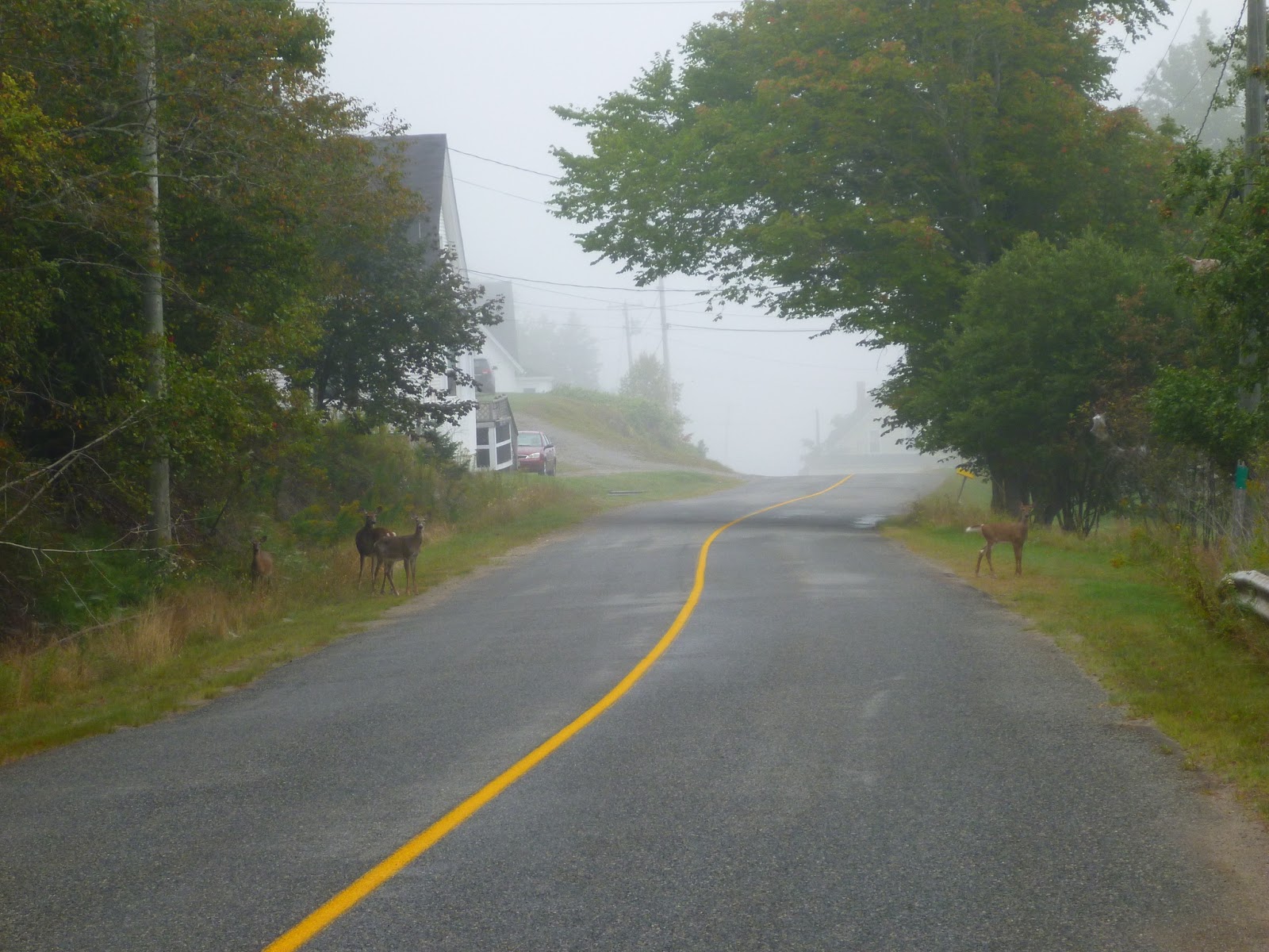
And I was right. I ended up riding round the delightful island behind a car in the lead followed by a truck who turned off just shy of the second ferry ramp at Deer Island Point Road that you can take to Campobello Island NB, or to Eastport Maine. Now I was behind just the car, and when the driver made the turn onto Deer Island Point Road, I could at last pass her safely, so I pulled out and shot ahead, up and around the corner, to see a herd of deer on the road ahead of me, so I pulled on the brakes, and the other car caught up to me in no time, and was forced to apply their brakes as well. I have no idea if they had seen the deer, and hope they don't think that I was brake checking them.
What I haven't mentioned is that I needed a washroom, fairly urgently in fact, and I thought for certain they would have a porta potty at the ferry terminal on the point, but it was devoid of any services, in fact is was the least imposing ferry site I've ever seen. Basically a stop sign on a beach, but I didn't linger, only long enough to take a picture...
Deer Island Point NB
I was now in a hurry, and thankfully there was no tracffic in front of me. I thought I'd see a restaurant or something now that I was on my way back to the main ferry terminal to head back to the mainland, and I even stopped on a fishing wharf and asked to find that there was a Johnny on the Spot back at the terminal, so off I raced, to round a corner and see more deer on the road ahead of me, but this time I was able to get some pictures of them.
Deer on Deer island. Who would have thought?
Proceed with care
They aren't too sure what to think of me yet
I'd hit the engine kill switch and rolled to a stop with the clutch pulled in, and they were content to stare at me for a few minutes, until I decided to start the bike and get closer for better shots... You can see the white tail up below as they bounded away for cover into the trees and fog.
Threat! Scatter!!!
I arrived at the terminal to find the ferry docked having a break, with a line of cars and trucks waiting for passage back to the mainland, and I scooted into the porta potty to find instant relief. *sigh* Thank god that is over. The sound of the ferry horn had me rushing to don my gloves and get myself sorted, and I kicked it into gear and rode out towards the ferry to find that it was almost completely full, the crew were in position to raise the ramp, and one of them waved me on to the last spot available where I gratefully acknowledged his quip about arriving in the nick of time, and shut off the bike for the trip back. :D
I studied Hydraulics in college and was interested in this solution to prevent the control valve from oxid in the salt sea air.
The downside, all these guys are going to be ahead of me on the road
Right away it became obvious that I was going to be tail end charlie off of the ferry, and would have to follow all of these vehicles back out to the highway before I'd be able to pass them one after another. Oh well, such is life.
And we're off!
Subaru, the new Prius/Volvo
Until I got stuck in behind this fella who drove abysmally slowly, and slowed down even further for the corners. Argh! I have a rule about safe passing opportunities, and will only do so with a clear line of sight ahead, and it took a quite a while before I could scoot on ahead of him and settle down to my usual touring pace of ten over posted.
I had been sharing my adventure on Instagram and Facebook under #rottenronniedotca and was receiving quite a few comments, and my cousin Becca saw that I was heading in her direction and told me to look her up when I got into Saint Andrews for a spot on the couch and to catch up, as I haven't seen her in ages. Seriously, I think she was playing on the swing set last time I saw her and her sister Gillian. (Was that last week? Lol). I guess she was under the impression that I was going to get there last night, so when I commented on her post, she told me that she would be working, and I asked if I could meet up with her on a break or something, to which she agreed. I have to admit I was pretty excited as I've been following her camping and photography for a while, and both Gillian and Becca have travelled in and around Atlantic Canada and shared some fantastic photos while doing so. Enough for me to credit them with being better at it than I am. :)
When she said "Algonquin Resort" I had thought my aging eyesight mistaken and double checked the entry for spelling errors, but there it was in black and white. Garmin found three hits, two of which I was expecting to find 1800 km away in Ontario, and one that was a couple of hours away from me up to the West as the crow flies, so I hit the main highway still wrapped in fog and settled in to make some time and distance as I wanted to get the visit in and still make it up to Hartland and then down to the outskirts of Saint John for my campsite graciously offered by my mate Zac.
Garmin. Back to that old topo map. It got confused by the new path of the highway at times, but generally agreed that I should get off the highway long before Saint Andrews, and there wasn't enough detail for me to make out that it was trying to route me south on 127 NB (East side) into the town, so I decided it must be optimistic, and clearly I needed to make more westing before southing, and ignored it's sage advice.
Hah! This put me heading south on 127 NB (West side) which follows the peninsula straight hey diddle diddle straight down the middle! into the town of Saint Andrews where I saw more and more out of province plates on the tourists cars. I also passed a Tim Horton's and resolved to return for a nice cuppa once I caught up with my cousin Becca.
Thicker fog as you get closer to the coast
I got turned around a bit once in the town, ended up on the Algonquin Golf Course, swallowed my pride and asked for directions, and was quite pleased when I put my kickstand down in the parking lot the resort. I wonder how the valet parking would have handled my Versys?
Wow. Now I'm feeling a bit out of place
The Algonquin Resort is now managed by Marriot hotels, and I felt really out of place there in the parking lot dressed in my riding gear, but I couldn't miss the opportunity to meet Becca, so I made my way into the lounge to find her serving the lunch crowd, and I begged to be allowed to sit out on the wet patio where I felt quite at home. I let Becca know that I was quite used to a damp seat, and after having ridden for a couple of days, she might want to spare the guests by letting me sit where I'd be downwind of them all. :P
They serve tea with a silver spoon here! I got stainless steel, 'cause Becca knows me too well
I even got a complimentary cuppa. It's great to have connections. :)
She got the good genes, All I got was the tattered old blue jeans
It was fabulous stealing a few moments to catch up with my cousin, but all too soon I felt that I was taking up too much of her time, and I really needed to get back on track if I were to get to Grand Bay later that day, so I said my farewells and retraced my route north on 127 NB to find the sun had come out, the fog burned away, and the day really shaping up to be a gorgeous one.
Northbound on 127 NB, and I've got the road to myself
But now I was really off my GPS track, and I quickly found that by staying on 127 I'd hook up with Route 3 and be able to get back on it soon enough. The roads north were fun, although as I'd been warned by Zac, fairly straight without much of a view.
Now I had another worry. Instead of refueling in Saint Andrews, I thought for sure that I'd be able to refuel up closer to the highway, but there was nothing and I'd carried on with three bars of fuel, which shortly on dropped to two bars left, and I figured I needed some gas in the next 50 km or so, or I'd find my self in a spot of bother.
I hit Route 3 which was a larger highway, that comes out in the small town of Lawrence Station, and a quick cast to the East showed no sign of gas, as did my trip to the West, but signs said I was only 32 km from Saint Stephens NB, the border town opposite Calais Maine, where I knew I'd find some fuel.
Garmin put my track north onto a secondary road Route 630 NB, and when I arrived at the crossroads I found a construction worker who told me that there was gas to be found in the town of MacAdam, which he estimated at a further 40 km north, but through a stretch of gravel construction area that I might prefer to avoid. I related my story of riding on the golf ball sized gravel yesterday morning, and he laughed and said I shouldn't have any problems with it then.
Andersonville United Baptist Church
Right, or rather left and straight on up the now familiar patched asphalt roads of New Brunswick and slap dash into the back of a couple of trucks at the flagman for the road construction.
It has to be an improvement
I needn't have worried about the road, as the worst of it was a fifteen meter bit of newly graded loose sand and rock, and by hanging back a bit from the slow moving vehicles, I simply rose from the seat and gave it some throttle in first gear, and launched the bike over it and onto a firmer gravelled surface where I passed the other trucks as soon as we cleared the flagman on the opposite end.
This is what a good road looks like.
They've a bit of work to do yet
It was only about 25 km up to McAdam, where Route 630 NB intersects with Route 4, then you have a choice to head left to the border into Maine, or right and on into the railroad town of McAdam. For such a small town it boasted a huge railway terminal, but as it was now 14:20 in the afternoon, I couldn't stop to play tourist and took this from the road on my way to the fuel station on the other side of town.
The area was first settled in the mid-to-late 19th century as a group of small lumber camps. The area further developed due to its advantageous location as an important railway junction between the main line of the Canadian Pacific Railway from the Maritime provinces to New England and central Canada and branch lines to St. Stephen, St. Andrews and Woodstock. The town was an important servicing stop for many passenger and freight trains, as well as military trains during the World Wars. A large railway station was built to accommodate travelers and a roundhouse and yard were located in the village. The conversion of locomotives from steam power to diesel during the 1950s, as well as highway improvements and increased trucking during the 1960s and 1970s, saw McAdam decline in importance for rail transport. Decreased employment with the railway caused significant economic challenges for the community during the latter half of the 20th century and early 21st century.
In 1900, the C.P rail began construction of the massive combined railway station/hotel in McAdam to cater to wealthy passengers changing trains to continue to the resort town of St. Andrews where they would stay at the C.P rail's hotel The Algonquin.
Canadian Pacific McAdam Station
Commissioned in 1901 as both a rail station and hotel
Right across from the pumps is Atlantic Canada's Largest Firearms Store, The Gun Dealer, and I couldn't resist heading in to see what they had inside, even though my days of gun toting were far behind me.
The Gun Dealer, McAdam NB
His and Hers model
"That is a Prince Edward Island Wolverine."
The store clerk proclaimed that the Wolverine pictured above was from Prince Edward Island, and if so it must have been a number of years ago as I've never heard of them living on the island.
I confirmed that the GPS track was north of Route 4, so retraced my route West until I had passed the clearly marked southbound Route 630 NB, and ran right into the international border separating Maine from New Brunswick, and as I didn't have my passport on me, it was just a u-turn for me, and I located the start of 630 NB which isn't signed very well at all, and headed north on the patched asphalt. The absence of a lane marker made me wonder if this was such a great idea, and a few kilometers later it turned to groomed gravel with the odd pothole.
Route 630 North of 4, NB
Diggity Stream NB
Diggity Stream NB
The gravel road led past a few hunting lodges, then past entrances to hunting camps, and gradually got narrower, as my GPS told me that I had 45.7 km to my next turn, I began to worry that I might be on a much longer Adventure by Garmin off into the unknown. My cell phone even welcomed me to the United States which, while comforting that I had signal in the event of the unforeseen, bothered me a bit as I don't have a roaming package, so any data that was being used would be pretty expensive for me.
I passed only two other vehicles on the road, one in the opposing direction heading from a lodge back out to civilization, and another loaded with brush headed my way that gave me plenty of room to pass.
But the road began to deteriorate, especially the uphill and downhill sections, as there were wash outs where water had run across the road, making for some wee ditches that were hard to see in the shadows cast by the trees, as well as exposed rocks that peeked up from the road, and were sure to give my front end a workout that I really didn't appreciate, so my speed dropped to less than 60 kph as I threaded me way around the rocks and odd pothole.
Through the heart of this, the trees began to thin out, and I could clearly make out the remains of numerous logging operations to the left and right, and I now understood why this road was in such good condition as it had to bear the weight of the logging trucks and support vehicles.
It also gave rise to the hope that the road didn't dead end up ahead somewhere, as it was nearing 1600 and I was halfway in according to the GPS, and my back was about halfway done in from the jolting. "Adventure isn't always fun while its happening."
Pavement and hydro! I might not be in a scene from Deliverance after all!
I have to admit I was pretty relieved when the gravel turned to pavement and I saw homes and hydro lines again, and shortly afterwards I came out into the small town of Canterbury NB where the 630 joins Route 122 NB north and leads out to the new Trans Canada 2, where I looked at the GPS to find I would really need to make some time if I were going to get to Hartland, cross that covered bridge and star my southward leg back towards Grand Bay and St. John.
The Trans Canada following the Saint John River
I made good time along the highway, although I kept my speed down to just above the posted limit of 110 kph, partly to be a good boy, and partly because I was enjoying not to have to scan the next twenty feet ahead of me for rocks, and this was essentially a nice break while still in the saddle. Just as it was starting to get boring and I was growing numb, the well signed directions to the World's longest covered bridge began to appear, and I headed East for a couple of kilometers until in the town proper.
The bike is loaded so heavily that I might not qualify as underweight!
Whoot! Made it! Crossing this bridge was going to put me onto Route 105 South which follows the Saint John River almost all the way into Fredericton NB.
Hartland NB
The World's longest covered bridge, Hartland NB
I have to admit that I was a bit of a bad boy, and lofted my front tire onto the bridge, then again at the opposite end. Lol. A hard right, and it was clear sailing out of Hartland, and on down the 105 along the river.
Riding south along Route 105 NB
The ride follows the Saint John River as it winds it's way roughly south east to empty into the Bay of Fundy, and I enjoyed the views and the road itself.
No secret this
It's a pretty popular route for motorcyclists, as evidenced by the number of bikes I encountered on the ride, no doubt the bulk of them out of Fredericton NB.
It's a New Brunswick road...
The surface deteriorates here and there, leaving patches upon patches in some places, and it really highlights the excellent maintenance of Nova Scotia in comparison to New Brunswick. I was regretting my poor front suspension and that extra click of preload that I'd added to the rear shock.
I found myself on better roads as I neared Nackawic NB, and a way point on my GPS to lead me to The World's Biggest Axe , where I stopped briefly for the photo below. I was running short on time as I needed to be in Grand Bay before sunset in order to find my friend's house and get my tent set up in his back yard. I dislike pitching tents and cooking in the dark.
Nackawic NB, home of the World's Biggest Axe
The plaque reads:
"The World's Largest Axe. This giant axe symbolizes the importance of the forest industry, past, present and future, to the Town of Nackawic and the Province of New Brunswick. 1991."
Truth be told, I never even got off the motorcycle for this photo.
I stopped again in Fredericton at, you guessed it, yet another Tim Hortons for a coffee and a danish, before deciding that I needed to make time, and the best way to do that would be to get onto Highway 2 and fast track towards Saint John on the highway as opposed to my earlier plan of taking a number of back roads to get there, that would have put me at my destination well after dark. I'll put part of the blame for this squarely on Garmin, as the route was listed as being under the 500km mark, but the time estimate to ride that track was clearly underestimated by a factor of at least a couple of hours. Highway it is!
They all begin to look the same... Fredericton NB
Just what I want to see, advertisements for Bullwinkle.
"I'm bored" selfie!
Sunset over Highway 7 NB
I kept looking over my shoulder at the setting sun, and would have loved to stop, but I found I was whizzing quickly past all the best places, so decided I needed to focus on keeping on.
The hills begin to get interesting again.
From Highway 2 onto Highway 7 it was a pretty straight run, but as the road gets closer to the Nerepis River, there are a few more elevation changes, and when it narrows back down to a single lane, it gets down right fun again, until you pull off into the riverside town of Grand Bay - Westfield NB.
Somewhere down there is a river valley.
At last I found his place, but I wasn't perfectly sure it was his house yet, so I merely unloaded my hard bags into the backyard, and asked his neighbour if there was a grocery store around, as I'd seen a BBQ in the backyard, and the thought of a hot steak was making me hungry.
They directed me to a Sobey's up the road a few kilometers, and I was able to get the steak and a bag of chips for later on. Out in the parking lot I bumped into Zac's brother-in-law Glen who I'd ridden with on the last Dawn 2 Dusk rally back in 2015?, ages ago or so it seemed. He made sure I had everything I needed, left me with his cell number, and I headed back to the BBQ armed with slightly less than fresh, last day of sale, half off steak.
Zesty kindling!
There was just enough propane left to get me my steak medium-well, just the way I like it, and I'd a couple of shots worth of whiskey that Brian had forgotten to drink last weekend at Meat Cove NS, so I was all set, but for vegetables.
mmm, Steak!
And this is my buddies driveway! If you like a smooth ride, New Brunswick may not be for you...
As I post trip pictures to Facebook so my friends can follow along, a particular person (who shall remain nameless) chides me about my poor dietary choices and constantly comments "Where are the vegetables?", so I came up with this stratagem: Carrots on top so I have to eat my vegetables before I am allowed to eat my dessert...
And, it works!
The food went down well, the clean up was easy, and I had my wet tent up while dinner was cooking so it was simply a matter of crawling into the sleeping bag and waiting for a new day to dawn...
Day 3 - Grand Bay Westfield NB to Borden-Carelton PE - 292 km
Day 3 - Grand Bay Westfield NB to Borden-Carelton PE - 292 km
I wasn't feeling terribly ambitious, and breakfast was simple matter of boiling up some water for instant oatmeal and a couple of mugs of tea, while I set upon taking down my now dry tent, and cleaning up all my scattered belongings. In fact, it had turned into rather a late morning, and I spent much longer than I had anticipated, and found that my early rising Aunt Sue had let me know that she and her husband had set off to work in Hampton, and were hoping to me me later today on my way back to the island, so my schedule was set, I had to be on my way and over to Hampton by 1300 if I were to meet them at Kredl's Corner Market.
Breakfast of champions!
But first I had to see the river that I had camped so close to last night... After going up and over the train tracks...
Looking south along Grand Bay NB
Saint John River as it meets Grand Bay NB
The flower garden
I couldn't help but play with some articles in the backyard, and this ride was very appealing to me.
Do you like the colour?
Of course I had to make a post or two in the Facebook group that I belong to:
And as many of them pull motorcycle trailers, I had to follow up with:
"Do you think it will handle the tongue weight?"
Double the storage of my Versys! And easier to corner too!
It was now after 11am and I really had to kick my butt into gear to get onto the ferry and cross the Saint John river and get on my way to Hampton.
Grand Bay NB
Once off of the ferry at Hardings Point, I hit Route 845 to the north, and found myself really enjoying the road as it follows the Saint John River on it's way down to Grand Bay. The hills and forest made for a wonderful ride, limited only by the road surface, and the thought of running into a herd of deer or a local on their way to or from church. I really should have taken a few more pictures of the road, but the shot below will have to serve to highlight how much fun this road is to ride.
A maritime roller coaster, Route 845 NB
Looking out over Isle of Pines towards Blue Mountain, across the Saint John River NB
Kingston Creek NB
Kingston Creek NB
And this is a good stretch of road!
Yeah, these roads... You are going to come home with chicken strips or in a tow truck.
My dad was born in Hampton NB, getting closer!
Which way? Left or right fork?
Cochrane Lake NB
845 NB is a popular loop out of Saint John NB
I'm coming home, folks!
The named a road and a town after the family. Probably because we get lost so often... :P
The closer I got to Hampton, the more and more I thought of my grandfather, Walter Martin Kierstead, and his young son, Emerson roving these same hills in search of lost cows, chickens, and firewood. My grandfather was a trucker, farmer, a butcher, a logger and he was also known to dig ice out of the river in winter for storage and later sale. A jack of many trades.
My Dad would have seen these hills time and time again as a boy.
And just around the bend and at the bottom of the hill, is Kredl's Corner Market in Hampton NB where my Aunt Sue and Uncle Ken spend their day in the bakery. For us, they start stoopid early in the morning so that all the bread you see is baked fresh, and they finish up by 1 pm, and as I'd arrived just minutes before the end of their shift at 12:45, I had a few minutes to kill before meeting up with my family.
Kredl's Corner Market
Aunt Sue and Uncle Ken
Try their sourdough bread, it is heavenly with very little "sour" to it at all. I could serve you a slice as white bread and you would never know that it had been cultured with soured starter.
Fantastic!
While I was waiting for them to finish up in the bakery, I treated myself to some Chicken Poutine from the food stand, and while a bit on the pricey side at over $11.00 after taxes, it was wonderful with fresh cut fries, a decent gravy and nicely spiced chicken.
Now these are Zucchinis!
It's a very popular stop for motorcyclists, and for a brief time the parking lot was full of motorcyclists enjoying the market.
I hadn't seen my Aunt Sue for years so it was a wonderful, albeit brief, time for me to catch up with family, and when she told me that my cousin Gillian was away in Hawaii on her honeymoon, I felt totally exonerated, as I'd already been through Fredericton last night. (You remember, I was in a rush?)
Family!
It turns out that my (new-to-me) Uncle Ken is a biker as well and rides an older Yamaha XJR, and enjoys Star Trek, so we had a lot in common and I really enjoyed sharing stories with them both, and as my Dad was due to visit out on the Island this coming week, I got us invited over for a visit so we could catch up with family and see the old neighbourhood again. I know Dad wants more ice cream from Kredls. :)
Right, time to get back on this two wheeled thing and haul butt back to the Island sometime this year...
The corner that the market sits on takes you into Hampton and then to the Trans Canada 1, or you can make a left and parallel the highway on a much more entertaining route that follows Ossekeag Creek and leads you back through Norton past Dickie Mountain where my grandfather had a hundred acres of rough farmland in the bush, and on down into Roachville on the outskirts of Sussex New Brunswick, which would appear to be the dairy capital of the province based on the sheer number of cow herds by the roadside.
Near Apohaqui on Route 121 East, NB
This is a long settled part of New Brunswick as evidenced by the number of older homes and barns you see from the roadside.
A very industrious family enterprise, fallen on hard times?
The farm above was an head turner, as it was immense compared to the smaller family run farms, and I can only imagine it's industry back in the day before its glory began to fade. Someone took pride in it at one point, as the detail of woodwork (gingerbread) is quite nice.
The iPhone's take on it...
Once again we take you across Smith Creek covered bridge.
Smith Creek #1 Tranton 1927
The roof protects these timber bridges from the elements.
I used to think they covered the bridges to keep snow off of them, and while that is true, it also shelters the bridge from all the elements, making them last four times longer than an uncovered wooden bridge.
Route 890 overlooking Pisgah and Goshen NB
By now I was pretty much retracing my route back into Moncton, and I hit the covered bridge
Smith Creek #5 Oldfields 1910
I'm relaxing more this afternoon, as my plan to ride all the nooks and crannies has gone with the flow, and I'm now quite happy to stop and admire the scenery as I locate some of old New Brunswick.
It's even got the curtains still on it
These horses were coming down the hill for some of the better grass down at the bottom near the road, and they seemed to ignore motorcyclists, as the dog up the hill failed to do.
Nom nom nom.
The mighty Petitcodiac River as seen from Route 890 NB near, of all places, Petitcodiac NB
Once out of Petitcodiac, I changed from the 890 onto the 106 that follows the Petitcodiac River all the way into Moncton, and I realized that I wanted to make a bit more time and avoid the city if I could this time.
One last picture before the highway
I did a u-turn and hopped onto Highway 2 and made tracks for the Tim Hortons in Salisbury NB, a favourite stop of mine, where I ran into Dana from Alma NB just on his way home from day trip around on his sportster. It turns out that we both served in the Canadian Armed Forces, so had a lot to talk about, especially as he ended his career in the military as a Search and Rescue technician (SAR Tech) and had turned that into a civilian job working for an oil rig or two I believe.
This is one Sportster that does some miles
I was going to head back through Sackville and see if my friend Courtney was a home, and while on the boring stretch of highway (they all are, aren't they?) wanted to document my new 16 tooth front sprocket at 130 kph indicated on the speedometer.
At 130 kilometres per hour indicated, the GPS shows a speed of 133 kilometres per hour, at just under 6,000 revolutions per minute. Not bad, and certainly nicer than the stock ratio for long highway hauls, but I really do prefer my 15 tooth sprocket for more oomph and the back roads. Especially the nasty back roads where I want more power in 2nd gear! Still, it does stretch it's highway legs if that is your thing.
I missed Courtney again, but had a nice chat with her neighbour who used to work for the Ministry of Transportation in New Brunswick, and we talked about the harsh winters and I enjoyed some of his tales about just how bad it could get before his retirement.
I had yet another excuse to ride High Marsh road! But I never even got out of town before I had to stop and get a few more photographs of some beautiful reminders of our past.
George Campbell and Sons, Carriage works, Middle Sackville NB
A search online found that this on the Tantramar Heritage Trust website:
Campbell purchased the Carriage Factory property from John Beal in 1855. Beal was a prominent tanner who had arrived from England in 1817. The 30' x 70' two story factory building was originally built in c1838 as a tannery and converted in 1855 (or before) to a Carriage Factory by Ronald Campbell and his son George. A few years later they added a blacksmith shop on the site. Thus was the start of a highly successful and respected business that was to last for nearly 100 years, finally closing its doors in 1950-51. (Campbell Carriage Factory Museum, Tantramar Heritage Trust, Al Smith, January 2003)
And across the street what looks like a plow or tractor shed
Jolicure Road looking North East towards Jolicure NB
These roads were well groomed and I was able to enjoy the zip across the marsh.
It's a gravel runner for sure.
United Church, Jolicure NB
And when I saw these girls snacking so close to the road, I couldn't help but kill the engine and coast to a stop to get a few pictures of them.
Keeping a wary eye on the bad boy biker
The bravest of the brave serves as rearguard as the others flee
All too soon I was back out on the asphalt running past Port Elgin to join the conga line of cagers and truckers heading back to the Island. I managed to get round the lot of them to pole position, where I quite happily managed to obey the speed limit in a general sense, and found myself back on 16 headed out to the confederation bridge, praying for some decent sunset light as I crossed through the marshy bit that had seemed so beautiful in the golden hour, but the light was of a different character this trip, and there wasn't the magic of the golden hour, so I kept on onto the bridge.
There is more of this... Lots more.
#thisishowweroll
Prince Edward Island is getting closer!
And at last a stop for a final tea before home!
This worked out much better in the mind's eye than on film(ish SDCard thingy)
Thanks for following along, and I hope to have some fall colours of New Brunswick in my next post. I'd really like to head down towards Alma again, along the Fundy shoreline, but also to visit Caledonia Mountain and up to Gowland Mountain, then take the 895 up into Salisbury or something similar. That being said, the Shepody Marsh is bound to be beautiful this time of year.


